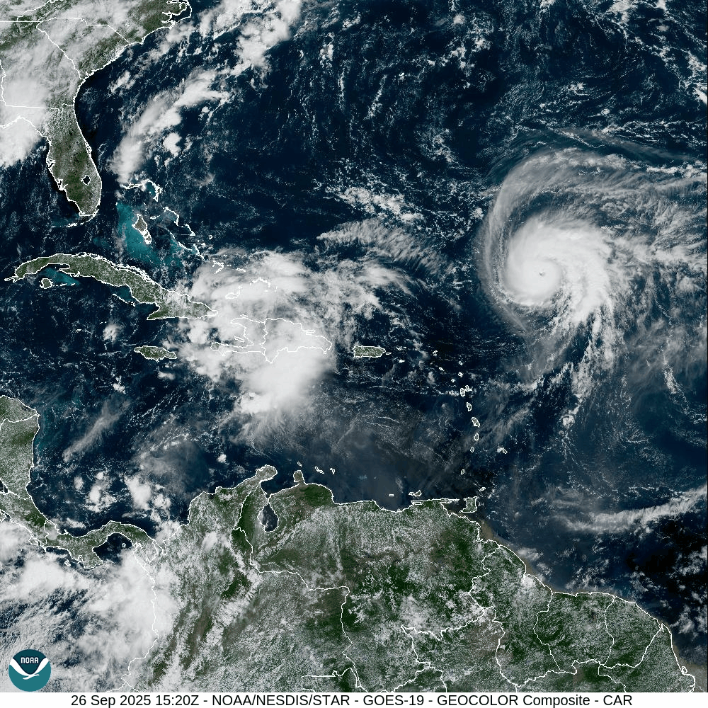
Figure 1: GOES 19 Visible Satellite imagery showing invest 94L near the southeast Bahamas and Hurricane Humberto undergoing rapid intensification over the Central Atlantic.
Overview:
A broad disturbance near the southeast Bahamas and eastern Cuba is currently developing, with a tropical depression likely within the next 24 to 48 hours near the central or northwest Bahamas. The National Hurricane Center lists formation chances at 90 percent through 48 hours and 90 percent through 7 days. Expect a general move across the central and northwest Bahamas this weekend, then a turn north to northwest over the western Atlantic early next week.
Forecast Discussion:
Steering is set by Atlantic ridging to the east and a trough over the eastern United States. Over the next 24 to 48 hours, the Atlantic ridging guides 94L north to northwest across the Bahamas while environmental conditions support development. From 48 hours onward, the track depends on the depth and timing of the trough and how quickly Atlantic ridging rebuilds from the east. The 12z GFS and Euro runs currently favor a more westerly solution that brings future Imelda closer to the coast of the Carolinas or Georgia (Figure 2), while the 12z Euro AI shows Humberto producing a weakness in the ridging, allowing Imelda to turn toward the northeast before reaching the Southeast coast (Figure 3). Humberto’s evolution is another factor that produces additional uncertainty to the forecast. A stronger or farther west Humberto in this scenario would result in Imelda being pulled north and east sooner, while a weaker or slower Humberto would allow ridging to nose west and nudge Imelda farther west. Confidence is high on near term genesis and a Bahamas passage, and lower on track specifics and intensity beyond day three. Because a defined core has not yet formed, changes in track or intensity are more likely than usual.
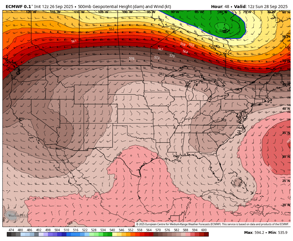
Figure 2: 12z European model 500 mb steering pattern showing future Imelda taking a more westerly track towards the coast of the Carolinas or Georgia.
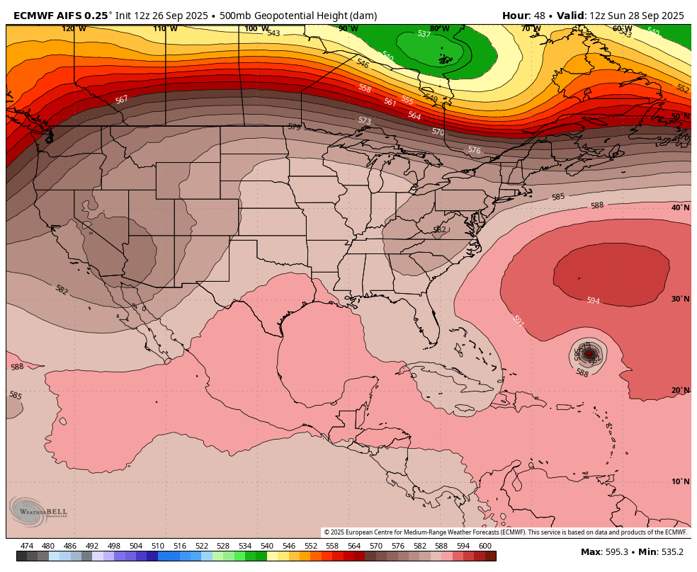
Figure 3: 12z Euro AI model 500 mb steering pattern showing Humberto producing a weakness in the ridging, allowing Imelda to make a northeastward turn before reaching the Southeast coast of the US.
Impacts:
Bahamas: Saturday 9/27 to Monday 9/29: Bands of heavy rain, gusty winds, rough seas, and dangerous rip currents, greatest over the central and northwest islands including Grand Bahama.
Southeast U.S. coast: Monday 9/29 through Friday 10/3: It is too soon to determine exact impacts for particular locations. Keep checking local National Weather Service forecasts, National Hurricane Center, and WxManBran.com for updates.
Preparedness Tips:
Check your 3 day kit today, water, medications, baby and pet needs, chargers, and simple foods.
Top off your gas tank to at least half and consider what loose yard items you may need to move in the event of having to make further preparations.
Know your evacuation and flood zones and how you will get alerts. Early steps help you avoid last minute crowds.
We will keep this steady and factual to keep you prepared. Doing your part in preparing now keeps families safe and reduces your stress levels!!
Next update: 9/26 at 8pm